Editor’s Note: This article originally appeared on TechRadar.
The dust has barely settled from Apple’s WWDC 2023 conference, and most people are, as predicted, fussing over Apple’s new Vision Pro AR goggles. The new Macs and other software updates got some attention at first but were quickly drowned out by the noise of the internet going gaga over Apple’s most recent hardware innovation, praising, mocking, and just generally meme-ing the heck out of it, seemingly in equal measure.
Regardless of my personal feelings about VR and AR, I think it’s hilarious that Apple can announce a Screen Distance feature and a device glued to your eyeballs not 30 minutes apart from each other.
But I’m not here to talk about Vision Pro, like everyone else. I want to talk about one of the watchOS 10 innovations that got somewhat glossed over during the presentation. I didn’t see much chatter about it online, but watchOS 10’s new hiking features seem truly excellent. We’ll have to get our hands on them in order to use them properly, of course, but combined with the power of the Apple Watch Ultra, it feels like Apple finally has a Garmin-beating marriage of outdoor-focused hardware and software on its hands.
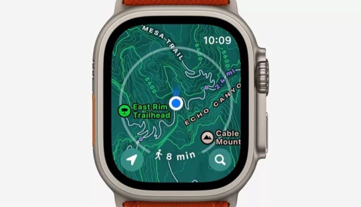
Topographical maps all across the US, with trail information including hill-shading, elevation, difficulty levels, points of interest and more, was an aspect of the presentation that was thrown out there with barely a mention but might cause trail-runners, hikers and other outdoor enthusiasts to do a double-take.
Most Garmins require topographical maps to be downloaded separately as GPX files using the Garmin Explore app, while more detailed satellite maps have to be purchased. At least for US users, Apple seems to have them all ready to go in the Maps app as a new view. It certainly made no mention of third-party downloads or additional purchases. Apple also intimated during the presentation that more countries were to follow.
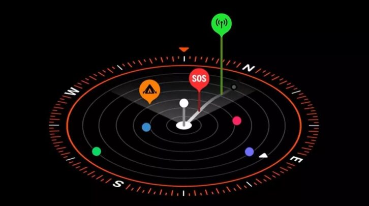
A 3D view of the compass Complication can display not only your elevation journey, showing you how high or low you’ve climbed so far, but offer automatically-generated waypoints based on the best place to make a phone call, directing you back to that spot in case you need help. Or want to call your loved ones and boast about how far you’ve walked that day.
It’s a great feature, combined with the Apple Watch Ultra’s excellent advanced compass, barometer and precision dual-frequency GPS, you’re likely to never get lost again. Combined with these features, the Ultra’s ear-splitting siren, durability, Night Mode and extra-long battery life could make it the consummate tool for overnight orienteers.

The Huawei Watch Ultimate, which has an excellent Expedition Mode, doesn’t reach the sort of heights we’re talking about. Garmins can get there, albeit with additional purchases and frequent switching of apps, and will last far longer in the field.
But I have a feeling that when watchOS 10 is combined with the Apple Watch Ultra, it could become a firm favourite for hikers everywhere.
About the Author
Matt is TechRadar’s expert on all things fitness, wellness and wearable tech. A former staffer at Men’s Health, he holds a Master’s Degree in journalism from Cardiff and has written for brands like Runner’s World, Women’s Health, Men’s Fitness, LiveScience and Fit&Well on everything fitness tech, exercise, nutrition and mental wellbeing. Matt’s a keen runner, ex-kickboxer, not averse to the odd yoga flow, and insists everyone should stretch every morning. When he’s not training or writing about health and fitness, he can be found reading doorstop-thick fantasy books with lots of fictional maps in them.
See also: Oura Ring 4 Tipped For Huge Upgrade So You Can Leave Your Phone Behind